Array
(
[id] => 1886f868-6c3a-4e97-9af9-0b2467f201ab
[version] => 14
[active] => 1
[publish] => 1
[created] => 2023-12-27 15:47:40
[lastmodified] => 2024-11-26 09:46:31
[createdby] => 44
[lastmodifiedby] => 44
[domain_id] => 6299
[office_id] =>
[menu_id] =>
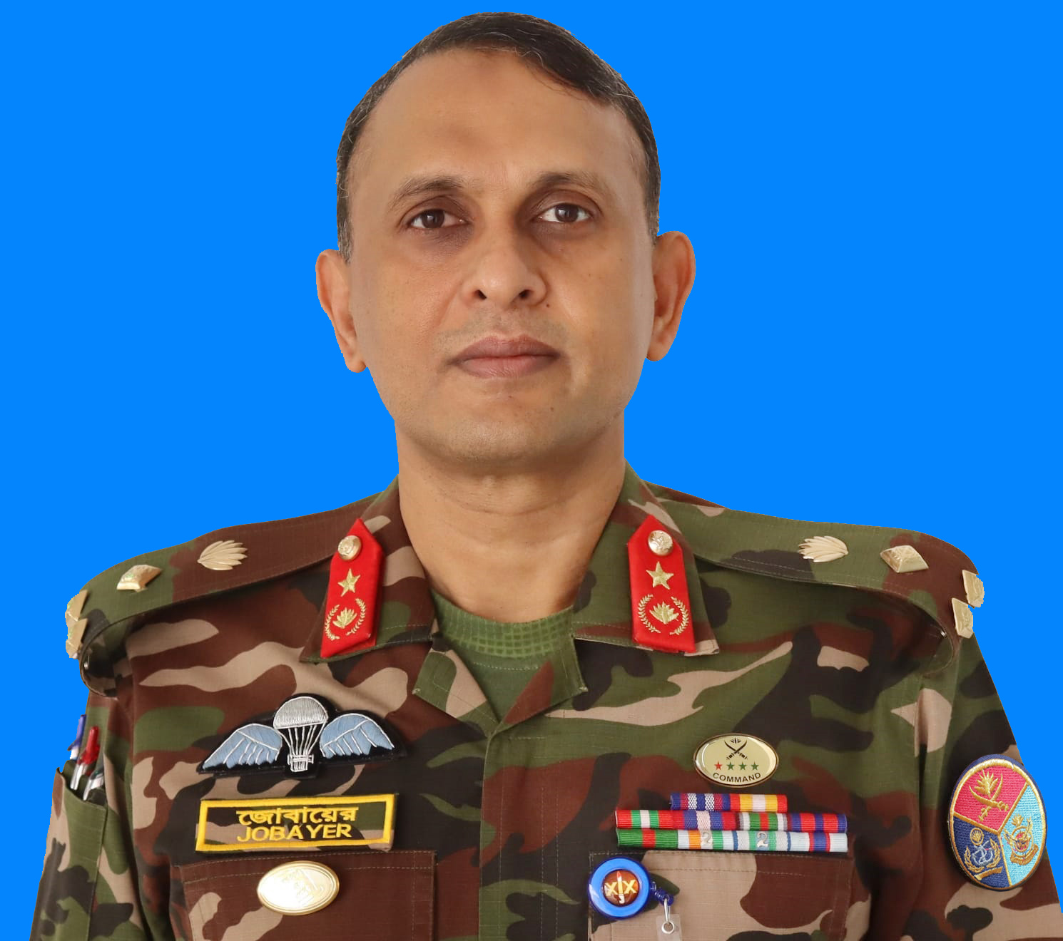
[title_bn] => ব্রিগেডিয়ার জেনারেল নুর-এ-আলম মোহাম্মদ যোবায়ের সারোয়ার, এনডিসি, পিএসসি
[title_en] => Brigadier General Nur-E-Alam Mohammad Jobayer Sarwar, ndc, psc
[body_bn] =>
[body_en] =>
[userpermissionsids] =>
[uploadpath] => 48d59705-2a06-4382-bab0-39e28ee08f06
[userip] => 127.0.0.1
[useragent] => Mozilla/5.0 (Windows NT 10.0; Win64; x64) AppleWebKit/537.36 (KHTML, like Gecko) Chrome/130.0.0.0 Safari/537.36
[usergeo] =>
[is_right_side_bar] => 0
[office_head_photo] => Array
(
[0] => Array
(
[name] => 2023-12-27-09-49-647f1da95c442b001d269bf1f38ff9fb.jpg
[caption_bn] =>
[caption_en] =>
[link] =>
)
)
[office_head_description] =>
[office_head_des_bn] => ব্রিগেডিয়ার জেনারেল নুর-এ-আলম মোহাম্মদ যোবায়ের সারোয়ার, এনডিসি, পিএসসি ২৯ মে ১৯৭২ কিশোরগঞ্জ জেলায় জন্ম গ্রহণ করেন। তিনি মির্জাপুর ক্যাডেট কলেজ থেকে ১৯৮৮ সালে এসএসসি এবং ১৯৯০ সালে এইচএসসি পরীক্ষায় উত্তীর্ণ হন।
তিনি ১৯৯১ সালে বাংলাদেশ মিলিটারি একাডেমিতে যোগ দেন এবং ১৯৯২ সালের ২০ ডিসেম্বর কমিশন লাভ করেন। তিনি ২৮ ডিসেম্বর ২০২৩ সাল থেকে প্রতিরক্ষা মপন্ত্রণালয়ের অধীনে বাংলাদেশ জরিপ অধিদপ্তরে সার্ভেয়ার জেনারেল অব বাংলাদেশ হিসাবে কর্তব্যরত আছেন।
তিনি বাংলাদেশ প্রকৌশল বিশ্ববিদ্যালয় (বুয়েট) থেকে ২০০২ সালে সিভিল ইঞ্জিনিয়ারিং বিষয়ে স্নাতক ডিগ্রি লাভ করেন। তিনি ২০০৪ সালে জাতীয় বিশ্ববিদ্যালয় থেকে মাস্টার অফ ডিফেন্স স্টাডি বিষয়ে স্নাতকোত্তর ডিগ্রি লাভ করেন। এ ছাড়াও তিনি বিখ্যাত ন্যাশনাল ডিফেন্স কলেজ (এনডিসি) এর একজন গ্রাজুয়েট।
তার দীর্ঘ মিলিটারি কর্মজীবনে তিনি বাংলাদেশ সেনাবাহিনীর বিভিন্ন প্রতিষ্ঠানে কখনো কমান্ডার, কখনো স্টাফ, কখনো ইন্সট্রাক্টর ইত্যাদি হিসাবে দায়িত্ব পালনের মাধ্যমে বৈচিত্রপূর্ণ ও মূল্যবান অভিজ্ঞতা অর্জন করেন। এ ছাড়াও তিনি Blue Helmet (UN) এর অধীনে তিনটি আলাদা আলাদা মিশনে কম্যান্ড এন্ড স্টাফ এপয়েন্টমেন্টে গুরুত্বপূর্ণ দায়িত্ব পালন করেন।
সেনাবাহিনী কর্মজীবনের বাইরেও তিনি দেশের জাতীয় গুরুত্বপূর্ণ অবকাঠামো পদ্মা বহুমুখী সেতু নির্মাণ প্রকল্প এবং পদ্মা রেল লিংক প্রকল্প নির্মাণে অবদান রাখেন। এ ছাড়াও তিনি পানি সম্পদ মন্ত্রণালয়ের অধীনে তিনটি গুরুত্বপূর্ণ প্রকল্পে প্রকল্প পরিচালক হিসাবে দায়িত্ব পালন করেন।
ব্যক্তিগত জীবনে তিনি বিবাহিত ও এক পুত্র সন্তানের জনক। তিনি বই পড়তে ভালোবাসেন, খেলাধুলা ও ভ্রমণে তার আগ্রহ রয়েছে।
[office_head_des_en] => Brigadier General Nur-E- Alam Mohammad Jobayer Sarwar, ndc, psc was born on 29th May 1972 in Kishoreganj district. He passed SSC and HSC examinations from Mirzapur Cadet College in 1988 and 1990 respectively.
He joined Bangladesh Military Academy in 1991 and was commissioned on 20th December 1992. Currently, he is serving as Surveyor General of Bangladesh at Survey of Bangladesh, Ministry of Defense from 28th December 2023.
He completed BSc Engineering (civil) degree from Bangladesh University of Engineering and Technology (BUET) from 1997 to 2002. He completed Master of Defence Study from National University from 2003 to 2004. He is also a graduate from the prestigious National Defence College (NDC).
In his long military career, he has obtained a mix of valuable experiences and knowledge by serving as Commander, Staff and Instructor in various institutions of Bangladesh Army. He also served under Blue Helmet (UN) in 3 different missions in command and staff appointment.
Besides Army service, he also contributed to Nation-building in Padma Multipurpose Bridge Project (PMBP) and Padma Bridge Rail Link Project (PBRLP). Also, he served as project Director of 3 important projects under the Water Resource Ministry.
He is married and the proud father of one son. He has a keen interest in reading books, sports and traveling.
[designation] =>
[designation_new_bn] => সার্ভেয়ার জেনারেল
[designation_new_en] => Surveyor General
[weight] => 1
)
=======================
সার্ভেয়ার জেনারেল
ব্রিগেডিয়ার জেনারেল নুর-এ-আলম মোহাম্মদ যোবায়ের সারোয়ার, এনডিসি, পিএসসি ...
বিস্তারিত
সামাজিক যোগাযোগ
জরুরি হেল্পলাইন নম্বর