


Map Services
|
Maps & Geospatial Information
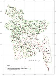
The whole land of Bangladesh is covered by about 9,80 sheets of national base map at a scale of 1:25,000. Preparation and updating of these topographical maps are essential for understanding the topography of the land as it is.
GIS science uses an infinite variety of mapped data, aerial photographs, digital elevation models, satellite imagery, and more to solve problems and answer questions. Geospatial information, which clarifies various characteristics of the Earth surface and contributes to the progress of geography and environmental studies, is developed.
Map data are also compiled and made available as digital maps for ready use on the computer fed as the base information in Geographic Information System (GIS). The digital maps are increasingly indispensable as information infrastructure to the IT society of today and tomorrow. |
|

|
Maps generated by Survey of Bangladesh:
1. Topographic Maps, Scale - 1:10,000Sample: 2. Topographic Maps (Open Series), Scale 1:25,000Dhaka: Sheet No. 79I/5A | Chattogram: Sheet No. 79N/15B 3. Topographic Maps (Restricted), Scale 1:5,0000Khulna: Sheet No. 79F/9 | Rajshahi: Sheet No. 78D/10 4. Topographic Maps (Restricted), Scale - 1:250,000 (Regional)Rangpur: Sheet No. 78G | Habigonj: Sheet No. 78P 5. District Maps (64 Districts) Sample: 6. Division Maps (8 Divisions)Sample: Mymensingh | Rangpur 7. COMMUNICATION MAP, Scale - 1:1,000,000 (Open for all)MAP of BANGLADESH (PDF) 8. MAP OF BANGLADESHBANGLADESH MAP with MARITIME BOUNDARY (PDF)
Maps Data Generated by Survey of Bangladesh:
9. GIS of the following Scales - Scale - 1:5,000 Scale - 1:25,000 Scale - 1:50,000 Scale 1:250,000
10. Guide Maps of Cities Sample: Dhaka (North) | Dhaka (South)
12. Ariel Photographs
13. Orthophoto
14. Digital Terrain Model (DTM)
15. Horizontal Control Point
16. BM (Bench Mark) Height
17. GNSS (CORS) Data and Services
18. Tidal Data
|
|
|||
|
Price and Order System: বর্তমানে ইন্টারনেটের সাহায্যে জিওডেটিক ডাটাসমুহর চাহিদা প্রদান এবং রকেট, বিকাশ ও শিওর ক্যাশ মোবাইল ব্যাংকিং এর মাধ্যমে মূল্য পরিশোধ সাপেক্ষে বাংলাদেশের যে কোন প্রান্ত থেকে ডাউনলোড করা যায় এবং অত্র অধিদপ্তরের সকল ম্যাপিং পরিসেবা ইন্টারনেটের মাধ্যমে গ্রাহকের দোরগোড়ায় পৌঁছে দেয়ার কার্যক্রম চলমান রয়েছে। To buy please follow the link below - |
||||


